
Circular shaped Iron Age Gallic village found in France using LIDAR technology
At Cap d’Erquy in the Côtes d’Armor region of France, satellite imaging technology has uncovered the remains of a circular village from the Iron Age.
In Cap d’Erquy, in the Côtes d’Armor region of France, the remains of a circular-shaped village from the Iron Age have been uncovered using satellite imaging technology.
The village consists of about twenty circular huts placed around a central square.
The village is believed to have been occupied by a Gaulish community between the 8th and 5th centuries BC.
The territory the ancient Gauls called home included parts of western Germany, northern Italy and Belgium, in addition to present-day France. A Celtic people, the Gauls were divided into multiple tribes and ruled by a landowning class in agrarian societies.
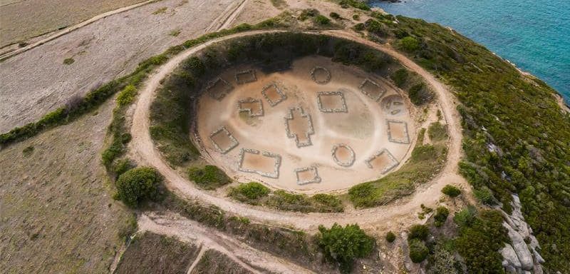
The tribes in Gaul operated independently of each other and only united in times of crisis. Each tribe had its own leaders and religion. During the Gallic Wars (58-50 BC), Julius Caesar led the Roman conquest of Gaul.
Jean-Yves Peskebrel, an archaeologist at INRAE (National Institute for e-realistic Archaeological Research) who participated in the studies, said: “This is an extraordinary discovery that allows us to better understand the daily life of Gauls in the Iron Age. This technology paves the way for important new discoveries and allows the exploration of previously inaccessible archaeological sites,” explains Jean-Yves Peskebrel, archaeologist at the INRAE.
Developed by INRAE, this technology, known as “LIDAR“, uses lasers to scan the ground and create volume reconstructions with unrivaled accuracy. This process makes it possible to detect buried structures invisible to the naked eye without the need for invasive excavations.
The discovery of the village of Cap d’Erquy is a spectacular example of the potential of LIDAR technology for archaeology. This technology paves the way for major discoveries and makes it possible to explore archaeological sites inaccessible to traditional excavations.
What is LIDAR Technology?
LIDAR (Light Detection and Ranging; or Laser Imaging Detection and Ranging) is similar to radar technology. While radar technology uses radio waves, LIDAR technology uses lasers. The distance to an object or a surface is determined using laser pulses sent to the target.
You may also like
- A 1700-year-old statue of Pan unearthed during the excavations at Polyeuktos in İstanbul
- The granary was found in the ancient city of Sebaste, founded by the first Roman emperor Augustus
- Donalar Kale Kapı Rock Tomb or Donalar Rock Tomb
- Theater emerges as works continue in ancient city of Perinthos
- Urartian King Argishti’s bronze shield revealed the name of an unknown country
- The religious center of Lycia, the ancient city of Letoon
- Who were the Luwians?
- A new study brings a fresh perspective on the Anatolian origin of the Indo-European languages
- Perhaps the oldest thermal treatment center in the world, which has been in continuous use for 2000 years -Basilica Therma Roman Bath or King’s Daughter-
- The largest synagogue of the ancient world, located in the ancient city of Sardis, is being restored






Leave a Reply