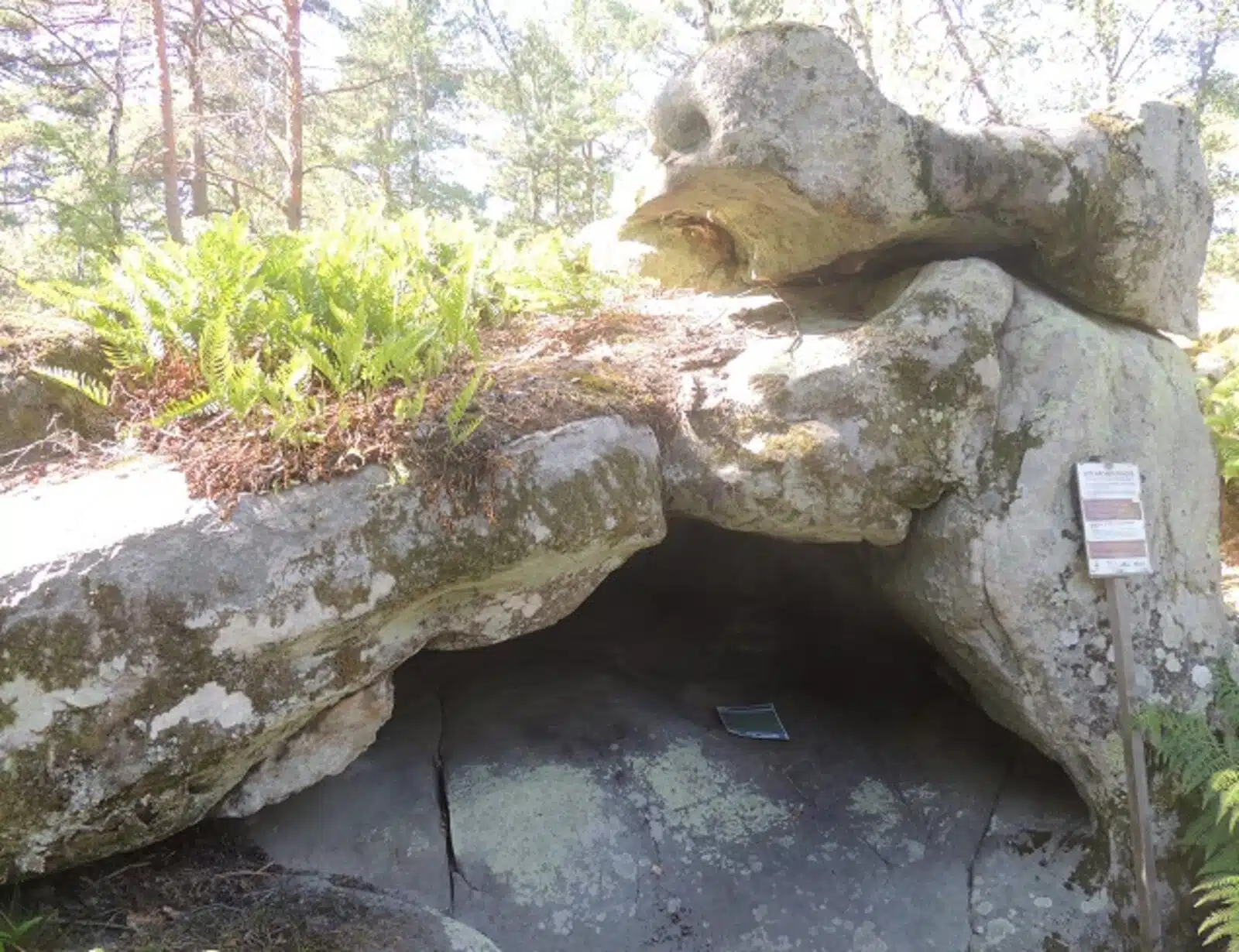
Researchers have discovered a distinctive engraving that may represent the oldest three-dimensional (3D) map known to exist
Researchers exploring the Ségognole 3 cave, situated in the renowned sandstone massif south of Paris, have uncovered a remarkable engraving that might be the oldest three-dimensional (3D) map in existence.
A recent study published in the Oxford Journal of Archaeology highlights how hunter-gatherers, over 20,000 years ago, modified the cave environment to depict water flow and possibly the surrounding landscape. Alongside the map, archaeologists discovered engravings of horses and the female human form, suggesting that the site may hold symbolic significance.
The research team, led by Médard Thiry and Anthony Milnes, proposes that the collection of engravings found in the cave serves as an artificial representation of the surrounding landscape, functioning as a sort of “scale model” that illustrates hydrological and geomorphological variations in the region.
This scale model of the Noisy-sur-École landscape is located on the floor behind the Ségognole 3 cave, showcasing an impressive level of detail and precision. The cave’s former inhabitants, hunter-gatherers, crafted a remarkable miniature representation of the area’s hydrological and geomorphological characteristics.
The researchers noted that the surface of the floor was skillfully engraved to direct water flow through meticulously designed channels, depressions, and basins. The specific indentations and slopes in the stone reflect the various hills in the region and their relationship to nearby rivers, lakes, and deltas.
“The carved motifs and their connection to the natural features in the sandstone of the shelter can be compared to significant geomorphological elements in the surrounding landscape,” the researchers stated.
Descubren el mapa tridimensional más antiguo del mundo en una cueva del Paleolítico cerca de París https://t.co/vcMGptjrbZ
— LBV Magazine (@lbv) January 3, 2025
The authors assert that the engravings found in the shelter may represent the earliest known three-dimensional map of a region, distinguishing it from other contemporary representations that were portable and two-dimensional.
These recent findings conclude an investigation into the cave’s engravings that began in 2020. Thiry and Milnes realized that all the water flowing through the cave’s grooves ultimately collected in a vulva-like depression, while other depressions and fractures directed water along different paths, indicating that the patterns within the cave held specific significance. They explained that rainwater entered through small surface fissures designed to capture precipitation directly from the wind.
Thus, the carvings and natural cracks symbolize both the surrounding landscape and the female form.
“The natural geomorphological features of the Ségognole 3 shelter provided an ideal setting to imprint this fragmented representation of femininity, a theme that was evidently significant during the Upper Paleolithic,” the researchers noted in their paper regarding the cave.
In addition to their hunting and gathering skills, Paleolithic hunter-gatherers exhibited a profound understanding of their environment and the ability to abstract and utilize it in practical ways, as demonstrated by the discoveries at Ségognole 3.
https://doi.org/10.1111/ojoa.12316
Cover Image Credit: SYGREF, CC BY-SA 4.0, via Wikimedia Commons
You may also like
- A 1700-year-old statue of Pan unearthed during the excavations at Polyeuktos in İstanbul
- The granary was found in the ancient city of Sebaste, founded by the first Roman emperor Augustus
- Donalar Kale Kapı Rock Tomb or Donalar Rock Tomb
- Theater emerges as works continue in ancient city of Perinthos
- Urartian King Argishti’s bronze shield revealed the name of an unknown country
- The religious center of Lycia, the ancient city of Letoon
- Who were the Luwians?
- A new study brings a fresh perspective on the Anatolian origin of the Indo-European languages
- Perhaps the oldest thermal treatment center in the world, which has been in continuous use for 2000 years -Basilica Therma Roman Bath or King’s Daughter-
- The largest synagogue of the ancient world, located in the ancient city of Sardis, is being restored




Leave a Reply